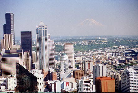
 |
| View
from the Needle of Seattle with Rainier in background. |
Mt St Helens, Washington - July 19-23, 2000
(This page
contains several images that may take a while to load,
you might want to go ahead and start reading...)
Well, here’s the plan…
Skip was going to Seattle for a web development seminar and would finish on Wednesday afternoon. Owen and I would fly into town, get a car and pick him up when he was through. We would stay in Longview, take a driving tour of Mt St Helens on Thursday, make the climb on Friday, tour Mt Rainier park on Saturday, fly home on Sunday.
That was the plan, here’s the story…
Day 1
Wednesday, July 19I picked Owen up at about 6: 15 am and we headed for the airport. Our flight left on time at 8:00 and we were headed for Seattle via Detroit. Owen used his GPS III on the plane and we were able to watch ourselves cross the country and monitor our speed and elevation. That was interesting and fun. During the approach to SeaTac, we had good views of Rainier and even caught a glimpse of St Helens off in the distance.
We arrived without incident, picked up our car (a Chevy Blazer) from National and were on the road toward Seattle by 3:15. Unable to find a parking spot on the street, we parked in the deck at Skip’s hotel (the Westin) and at about 4:00, bought tickets for the monorail out to the Space Needle. It was a pretty clear day and we could just see Rainier through the haze over the city skyline. We were currently having days with temperatures near or over 100° back home and the highs in the 70’s here were a refreshing change.
 |
| View
from the Needle of Seattle with Rainier in background. |
After a while at the needle, we headed back toward the hotel and were waiting on the steps when Skip called on the FRS radio at 5:30. We loaded his stuff in the car and drove up to the REI store. We looked around there for a while and then headed down to pier 57 to The Crab Pot for dinner. I had some excellent grilled salmon at the Paradise Inn when I was in the area a couple of years ago and so decided to try it again, this time it was only so-so.
After dinner we headed south to The Red Lion Hotel in Longview. Here’s where we would spend the next three nights. We had nice views of Rainier during sunset as we drove out of town.
We eventually got organized in the room (Owen volunteered for the roll-away) and Skip hooked up his computer so we could send an email to friends at home. It was midnight by the time we finished all this.
Day 2 Thursday, July 20
We left the hotel around 7:30 am, stopped at Burger King for breakfast, then drove toward Cougar where we would get our climbing permits at Jack’s Restaurant and Country Store.
|
|
|
Jack's Restaurant, where you register and get your climbing permit. |
From here we turned back north and drove to the other end of the park and made a stop for a quick tour of the Visitor’s Center. The morning had been overcast up until now, but was beginning to clear. From the Visitor’s Center we proceeded on to the Forest Learning Center, then the Coldwater Observatory where we had lunch (a Mt St Helens burger for me) and took several photos. There was a nice flowery meadow with a trail passing through it and good views of the mountain. Then on to the Johnston Ridge Observatory. Here we also did a quick walk-through and then caught the next showing of their movie "A Message From the Mountain". At the end of the movie, a huge curtain lifts to reveal a view of the mountain and blast zone, it’s an effective ending. After the movie we walked outside and up the trail leading to a viewpoint on top of the ridge. From here, 5 miles from the mountain, we could see into the crater and had an expansive view of the blast zone. Around the area were the splintered stumps of huge trees that were shattered and carried away by the force of the eruption. It’s quite an impressive site.
We made our way back into Longview and had dinner at Denny’s. I decided to give the salmon another try and it was better this time, but still not what I had hoped for. We arrived back at the hotel around 7:45 pm and began readying our gear for the next day’s climb. We then sent another email back home with a couple photos attached (thanks to Owen’s digital camera) and climbed into bed at 9:30.
Day 3 Friday, July 21
Beep beep!.. Beep beep!.. Beep beep!.. my watch alarm was sounding, it was 1:30 am. After only 4 hours sleep, we were moving slowly at first, but got up, gobbled some breakfast, gathered our gear and were out the door by 2:15. We were pleased to see stars and the waning moon shining brightly in the sky. The drive to Climber’s Bivouac was uneventful except for seeing a few deer along the way, as we had the day before on the way to Cougar. We arrived at 3:30 and it was 55° .
|
|
|
Hittin' the trail at 4:15 am. |
There were a few trucks parked around and we assumed most of them held soon-to-be climbers. We got ready and headed over to the trailhead for the obligatory "starting out" photo and at 4:15, took our first steps toward the mountain.
Soon after entering the woods, we began to see large patches of snow on the ground. The well worn trail climbed gently and the very humid air was enough to cause us to break a sweat. We stopped for a break at the outhouse just past the intersection with the Loowit trail and by now there was ample light so we put away our headlamps. We continued on and were just above timberline when the sun crept over the horizon behind Mt Adams. The resulting lighting was very dramatic on Mt Hood so we stopped to do some photography.
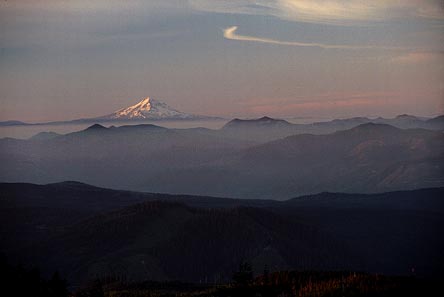 |
|
Sunrise on Mt Hood. |
At this point the scrambling began as we made our way up onto the lava flow that is Monitor Ridge. We soon stowed our trekking poles as it became necessary to use our hands for balance and climbing over rocks. The going was slow and cumbersome as we worked our way over and around boulder after boulder. We loosely followed the trail marked by the wooden posts as we made our way further up the ridge.
For a while we were on the western side of the ridge and so in it’s shadow. When we worked our way up onto the top, we had to don sunglasses as the sun was very bright. After a while we were able to step off the ridge on the eastern side and walk up a snowfield. The going was a bit easier but since we were not equipped with ice axes, we had to be very careful. The snow was very firm and it was hard to kick in a good step so at the steepest sections, we would get back on the rocks for safety.
We took a long break by the second monitor tripod and ate, drank and of course shot some video and photos. We were enjoying the view of Mt Hood which was 62 miles away, when we noticed we could see yet another mountain in the same direction. Later we would learn that it was Mt Jefferson, 106 miles away. As we turned to look uphill, we could see people standing on the crater rim from here and it still looked like a long way up there.
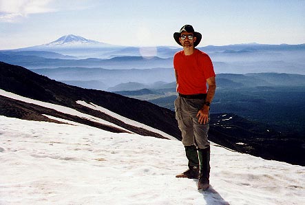 |
|
Yours truly taking a break near the
second monitor tripod. |
As we proceeded, the terrain changed from rocky to one covered with ash, pumice and pulverized lava rock. This was very loose and a few inches deep in most places and it made the going tough. As I have read on others’ accounts of this climb, it seemed you would "walk up two steps and slide back one". The angle of the trail is pretty steep and constantly having to fight to keep your footing really saps the energy from your legs. I was glad I had my trekking poles to employ for some extra push with my upper body and to aide in balance. I started rest-stepping and that seemed to help from tiring my legs so.
Skip called on the radio (we were all carrying our FRS radios) and said that he was stopping to apply sunscreen. I turned to see where he was and realized I had gotten ahead of him and Owen, but Owen was not far behind me and continued climbing. I continued on as well. A while later, I again turned to see where they were and they had stopped for a break. It seems Skip’s Achilles tendons were bothering him and he didn’t want to push too hard. Owen decided to stay back with him.
I reached the crater rim at 10:22. I radioed to the others I was here but would wait on them before going over to the true summit. The wind was really strong along the edge so I walked over to a place where there were a few other people sitting, just below the rim and behind the snow cornice. It was amazing how just a few feet below the edge there was no wind at all. I sat there snacking and drinking and overlooking the lava dome and enjoying the tremendous view of Mt Rainier and Spirit Lake. Again I was thankful we had such a beautiful day for our climb. It was 56° on top and the wind made it just cool enough to wear my shell.
I got up to check on the others and saw that they were almost at the top now. I grabbed the video camera and walked down to where the trail tops out and videoed them as they reached the rim. It was 10:47. We all sat down and ate lunch and took a well deserved break.
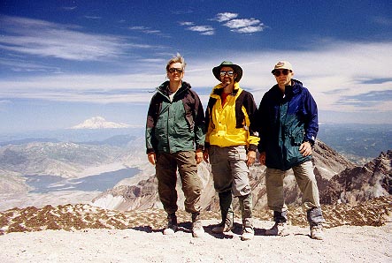 |
 |
|
|
Standing on the crater rim - Owen,
Ron, Skip |
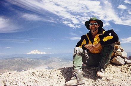
Me sitting by the summit cairn - 8,365 ft |
We started for the true summit, but upon seeing the route over to it, Owen and Skip decided not to go, and I had second thoughts myself. However I decided to go ahead on my own, but was really feeling fatigued as I made my way over. There is a "notch" of sorts along the edge of the rim and you have to lose and regain considerable elevation. Plus, the footing is even more loose than was on the trail coming up and that made it even harder. But finally I did reach it and set up my camera on the tripod to take a photo of myself by the summit cairn. I also made a video entry. Shortly after I started back, I met a man and his dog coming over. The dog’s name was Brody and coincidentally, he was the same mix as my dog Max, half chocolate Lab and half Springer Spaniel. The man said that Brody loved to hike and would eat snow on the way up for water. He seemed to be doing fine.
 |
|
Here is a 180 degree view from the crater rim. Note the new lava dome forming in the crater. |
I started on my way back to where the others were but stopped at the bottom of the "notch" to photograph and video the lava dome as here was a view not obstructed by the snow cornice. When I leaned over the edge of the rim for the video, I was sandblasted with dust and grit. There seemed to be a constant flow of it blowing up the crater edge, you could lean out into it or back out of it.
I arrived back to where the others were and took another break. While there, who should come by but our old friends The Blue Angels! They appeared to be making photo runs in front of Mt Adams and although they never got very close to us, you could certainly tell it was them. I got a pretty good video shot of them passing by.
I need to say more about the dust and grit. As I said before, it was very windy right along the edge and there was a constant supply of dust getting blown into everything…eyes, nose, mouth. My glacier glasses did a good enough job of protecting my eyes which I had wondered about, since I wear contacts, but we were most concerned about our photo and video equipment. The cameras were covered with dust before we left the summit and you could hear the grit when you extended or collapsed the legs on a tripod. Skip had just bought a Nikon N80 and this was only his second roll of film to shoot with it.
Well, after even more pictures (including one of us with a "Stay In It" sign to send to Rick & Bubba) we decided it was time to start down. We left the crater rim at 1:45 pm.
 |
|
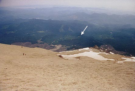
Looking down from the rim, the arrow denotes Climbers Bivouac. Note the depth of the footprints in the ash near the top. |
The trip down was hot and dusty. At one point I set up the video camera on my tripod to do a "walk-by" shot, and as I was leaving from behind the camera to get in position, my trekking pole slipped and I felt it hit something behind me. I thought "was that the…?? …nah", but turned around just in time to see the tripod tilting over and then Owen’s video camera crashing to the ground. Fortunately, it appears to have come through the event unscathed and still in working order.
As soon as we were able, we moved off the rocks on to a snowfield. The going was easier here and we were able to plunge our heels in for firm footing. Eventually we came to an area where some people were glissading. Again, not having an ice axe I chose to walk down the first place, but behind me, Skip decided to give it a go. He did fine and easily controlled his speed by using his feet. We stayed on the snow as long as we could and had four more opportunities to glissade and each of us took advantage of them. Although a bit cold on the bottom, it was a refreshing break.
The sun was really strong and despite sunscreen, we all were showing the effects here and there. Owen and I were about out of water (and did run out before we got back to the car) so we were glad when we finally reached treeline again and were able to get in some shade. But shade came with a price… mosquitoes! They weren’t so bad as long as you were moving but if you stopped, they found you quickly. The rest of the hike back down to the car was uneventful but seemed long. I remember my shoulders in particular hurting, I guess I had overloaded my day pack. We reached the trailhead at 6:20 pm, 14 hours and 5 minutes after we started up.
We stopped at Jack’s for dinner on the drive out. The food was pretty good but it was the first time I had ever been served tartar sauce with chicken fingers. Y’know, it wasn’t bad.
Upon arrival back at our hotel, Skip and Owen began the process of loading the digital photos in the computer so we could send a message back home. After we each got a shower (a very welcomed shower, I might add) we reviewed Skip’s video and I composed a lengthy message to go with the photos, but we would later learn that something failed and no one got it.
Day 4 Saturday, July 22
A thunderstorm had rumbled through during the night and it was still heavily overcast as we loaded our stuff in the car. Today we would drive to Mt Rainier National Park and tour it. On our way, we stopped for lunch in Packwood at a small "mom & pop" diner. I can’t remember the name other than it said "Pizza and Ice Cream" on the outside. However, the food was good. We entered the park through the Stevens Canyon entrance and stopped at the Grove of the Patriarchs. This was a nice walk through a grove of huge trees and the cloudy, rainy day made the forest seem even more deep and dark. (Click here for those pictures)
From here we drove toward Paradise, stopping to photograph a waterfall or two along the way. At Paradise, we toured the visitor’s center and then took a quick look at the lodge. The fire in the lobby felt good since it was about 47° and so damp outside. We wanted to go in the RMI guide house but they were closed. The mountain stayed hidden in the clouds the whole time we were in the park and so again, just like two years ago when I was here to climb, I never got to see it.
We left the park and drove to the Nisqually Lodge where we would spend the night. We went to dinner at Rainier Overlander and once more, for the third time, I decided to give the grilled salmon a try. This time, it was delicious, just like I remembered from before. Back in the room, we reviewed the video I had shot on the trip and packed up for tomorrow’s departure. Tonight was my turn on the roll-away.
Day 5 Sunday, July 23
We took advantage of the continental breakfast and then loaded the car and headed out for the airport. The flights home went smoothly with the exception of our flight out of Detroit being delayed about an hour due to a faulty oil filter sensor having to be changed.
I had the window seat out of Detroit and was facing west. I watched the sun set from 30,000 feet and thought of Suzie, who was in Wyoming on a mission trip. I wondered how things were going with her and realized it would be another week before I would see her again.
Allison and the girls met us at the airport to get Skip. Owen and I loaded up in my car and headed home. I dropped him off and finally was home about 10:45 pm. It was good to see the dogs again and sleep in my own bed. I was glad I had scheduled the next day off work.
* * * * *
A little more climbing info...
What I carried:
A daypack loaded with –
Lunch & snacks
2.5 liters water
16 oz soft drink
first aid kit
shell jacket
shell pants
Polartec 100 shirt
lightweight gloves
35mm camera & flash
8mm video camera
tripod
hat
glacier glasses
headlight
knee braces
What I wore:
Coolmax T-shirt
Nylon Supplex Zip-Leg* Pants (* a handy feature)
Leather boots
Gaiters
Hat (for shade, when I wasn’t carrying it)
What I carried but did not use:
First aid kit -(thank goodness) Rarely need it
but always have it anyway.
Shell pants - I had these in case the weather turned ugly or for
use in glissading. However, by the time we had the opportunity to glissade, I
was so hot and tired that I didn’t want to take the time to put them on.
Besides, since I was wearing absolutely no cotton, (yes, even my
underwear was Thermax) I was completely dry well before we reached the car.
Polartec 100 shirt – I wasn’t sure how cold it would be at the summit,
and again, if the weather turned ugly…
Gloves – Just wasn’t cold enough.
Knee Braces – (thank goodness again) Looks like a little
training pays off.
I used everything else at one time or another, as well as trekking poles. Now, certainly all of this is not necessary to climb the mountain, especially all the photographic equipment, but photography is something I really enjoy doing while I’m outdoors. Also, I can’t think of anything I needed but didn’t have, except maybe more water.

View from Climber's Bivouac, the red line
shows our approximate route up
Click here to go to my Mt St Helens photo
gallery
For another perspective on the climb, and more photos, visit
Skip's site and Owen's
Place
Trip Reports Home Page Rainier Page
Copyright © Ron Burkett 2000 All rights reserved